How can urban environments be better prepared for the increasing risk of flooding?
The answer lies increasingly in the combination of quality data, accurate modelling, timely warning and concrete actions on the ground.
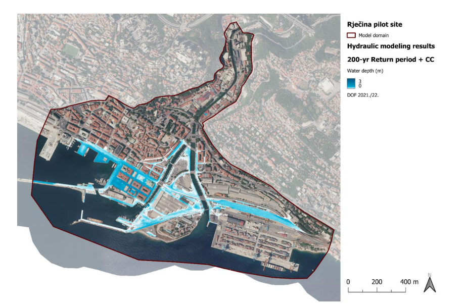
This approach is being developed through the project. URBANFLOODS nine pilot areas across the Adriatic-Ionian region. One of them is the Rijeka area of Rječina, This is why the development of new tools and approaches to flood risk management is also directly linked to the local context of Rijeka.
What can the data tell us before the water rises?
One of the important steps is Flood modelling in all nine pilot areas. Hydrological data are used to produce hazard maps that show which areas are more exposed to risk and form the basis for the development of early warning systems. This data will be linked through a decision support system (Decision Support System - DSS), which aims to enable better risk monitoring and more timely decision-making.
The goal is not only to know where there is a risk of flooding, but convert available data into information that can be used before and during potentially dangerous situations.
From model to field data
In order for early warning systems to be useful, models need quality data from the field.
Pilot site Fosso Terria in Italy real-time water level monitoring equipment is installed, while in the area Modica-Scicli Two hydrometers installed to enable timely activation of the warning.
For the Karas River in Serbia the hydrological assessment and flood risk study have been completed, and for the Lana and Tirana Rivers in Albania hydraulic models and hazard mapping are completed.
Different pilot sites thus test different parts of the same approach, better understand the risk, monitor what is happening on the ground and react in time.
From project results to long-term application
An important part of the story is how to transfer developed solutions from project activities to actual flood risk management.
That is why technical results such as models, hazard maps, sensor data and decision support systems are also linked to public policy recommendations. The aim is that the tools developed and the knowledge acquired will remain applicable after the end of the project and can help local and regional authorities in planning and decision-making.
This topic is particularly relevant to Rijeka because of Rice as one of the URBANFLOODS pilot areas. Experiences gathered at different locations allow for a comparison of approaches and the development of solutions that take into account different local conditions and risks.
You can read more about current results, pilot sites and the development of early warning systems in: the 4th edition of the URBANFLOODS Newsletter.